

SoCal Six-Packs of Peaks challenge #3 “Mt. San Antonio Peak” -Mt. Baldy
ATTENTION: Special Events are different than our regular club runs and are for current club members only!
MOUNT SAN ANTONIO (MT BALDY) – Elevation 10,064′ (3,068m)
Unmatched views, Devils backbone trail, limber pines, highest point in LA.
11.5 miles – 4300 ft elevation gain
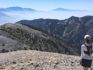
Kate enjoying the Mt. Baldy summit view.
The path is grand, it starts on the road to beautiful San Antonio Falls.
After a little less than a mile we move onto a single track technical trail on our left, the “Ski Hut Trail”, that will get our heart pounding the moment we set foot on it. Rapidly we’ll reach the Ski Hut (8200′) and cross the Baldy bowl. There are a couple of places where the trail is a little difficult to find, but if you look for the obvious, you should be able to manage. The last mile to the top is a butt-kicker.
We come out at the Mount San Antonio Pk. with an elevation of 10,064ft. After making the obligatory pictures you can make a short trip to West Baldy on the left. Then you head back to Mt. San Antonio Pk. and continue on the Devils Backbone Trail that is technical, steep with lots of loose rocks, take it easy and make sure to stop and enjoy the views! After 3.2miles we will have reached the Mt.Baldy Notch (restaurant/bar), here you can refill your packs inside and even buy a snack or two. From there we head back on the Miners Bowl trail and Manker Canyon road, these are fire dirt roads that will bring you back quickly to where we started (4 miles downhill running).
If you feel that you’re not ready to go back yet after your refueling break at the Notch, then go for the short (but steep!) out&back to Thunder Mtn. (+3miles total) and/or Telegraph Peak (+5.5miles total) before heading down on Manker Canyon road. But please make sure we know so we’re not just waiting and worrying about you!
Where to meet: at the bottom of Manker “Falls” road. See google map: https://goo.gl/maps/4YFJG
How to get there: Get to the I-210E (Foothill Fwy). Continue onto CA-210/Foothill Fwy/San Bernardino. Take the exit toward Base Line Baldy rd, turn LEFT onto East Base Line rd. Take the 1st RIGHT onto Padua Avenue, continue for 1.8miles. Turn RIGHT onto Mt.Baldy rd., in 10miles stay RIGHT to stay onto Mt.Baldy rd., in 1.5miles stay LEFT to stay on Mt.Baldy rd., in 100 yards you’ve reached your destination. Try to find parking along the road or the designated parking spots.
Wanna read more about the SoCal Six-Pack Challenge ?
Wanna read more about this route on SoCal hiker ?
Trail Runners Club Strava map with elevation profile.